Geographic Information Systems and IT solutions for the environment
Geographic Information Systems and IT solutions for the environment
Welcome to our product page! Here you will be able to download trial versions of our software and to buy it online with a few easy and secure steps. We now accept PayPal payments, thus you will be able to pay with any of the major credit cards! Do not hesitate to contact us for technical support or products enquiries!
![]()
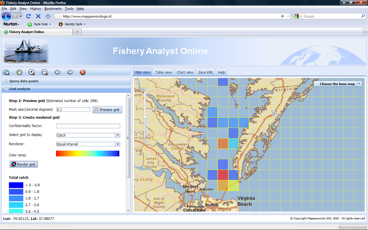
Fishery Analyst Online version 3.0 is a web GIS application aiming to effectively query fishery data, analyze and visualize temporal and spatial patterns of fishery dynamics. The main functions are quantitative estimation and visualization of catch, effort, fishing success and their variation in space and time. The application can easily read any type of geo-referenced fishery data. Data can be searched and selected using a rich query interface based on criteria such as region, event, date, caught species, and gear or catch characteristics. Parameters such as catch and effort can be then aggregated on a user defined grid. Data are also displayed in table format and plotted in bar or pie charts.
Fishery analyst Online was born as a web adaptation of Fishery Analyst for ArcGIS Desktop. The online version aims to take advantage of the new web based technologies offering improved accessibility, data sharing, integration, centralization and resources optimization beside new functionalities. Institutions such as national, federal and international agencies and universities working in the domain of fishery science and management will benefit from this application.
The application was developed using various JavaScript APIs and the Dojo framework. It does not require any third party software making it an easy accessible and affordable web GIS solution offering advanced features.
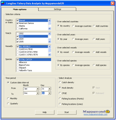
Fishery Analyst for ArcGIS 9.x and 10 is an application developed to effectively analyze and visualize temporal and spatial patterns of fishery dynamics. The main functions are quantitative estimation and visualization of catch and effort and their variation in space and time, analysis of fishing vessel utilization, data quality control, and deriving information on the location of important economic and threatened species. The application provides a user-friendly analysis interface allowing for easy and diverse output production. The interface allows the user to choose the analysis to perform (effort, catch density, catch per unit of effort etc) and to select data on criteria such as year, vessel name and/or size, and fish species caught. The output can be generated as yearly, monthly, quarterly or user-defined date interval plots. Results can be plotted in pre-defined map layouts and saved in quantitative GIS data file formats (raster and vector) or as graphic files and times series animations. The application provides an option to produce non-confidential plots for data protected by confidentiality policies. Click here to read more

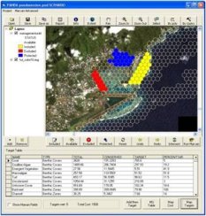
PANDA is a stand-alone application developed using Visual Basic and ArcObjects. It was developed to provide a user friendly framework for systematic protected areas network design to ArcGIS users. Through the use of PANDA. the designer can explore different hypothetical configurations of a system of protected areas in the planning area. Conservation achievements and associated costs of each scenario are based on the available data and knowledge. The designer can edit the scenario by interactively modifying the status of the planning units among 4 managed categories (Included, Protected, Available, Excluded). He can then explore the target table to see the resulting changes in conservation achievements of the new scenario and the associated costs. PANDA allows interacting with the software MARXAN by providing an easy way to run Marxan over the current scenario and display the results into ArcGIS format. ArcGIS data files are converted to and from Marxan data files in the background. The user can then use PANDA main interface to refine Marxan solutions. Conservation features distribution, cost and Marxan irreplaceability score can be easily mapped by pressing the corresponding buttons. Auxiliary tools involved in systematic conservation network design will be provided in next PANDA release, including a tool to generate a grid of management units of the desired shape and size and an easy interface to add new conservation features and targets. Click here to read more
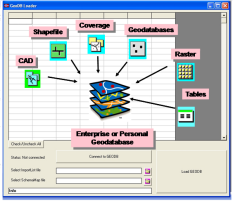
The GEODB Loader is an ArcObjects application for ArcGIS 9.x aiming to automate and speed up the process of converting and transferring spatial data from file based storage formats to a Personal or Enterprise Geodatabase or between Geodatabases. It is suited for both, one time operations, as well as for routine updates of a geodatabase. It allows all the following: Mapping each input dataset (shapefile, featureclass, other spatial format supported by ArcGIS) to a corresponding featureclass in the output geodatabase; Mapping each input attribute to one ore more corresponding attributes in an output featureclass in the geodatabase; Mapping input attribute values to new output values (e.g. to convert input values to standardized values); Creating additional attributes and populate them with new values (constant values or values from an input attribute); Mapping and/or creating joined standalone tables;
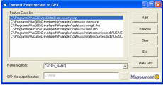
The GPX Converter is an ArcObjects Application that allows for easy conversion of your GIS data (shapefiles, feature classes in a geodatabase) to GPX format (the GPS Exchange Format). GPX is a light-weight XML data format for the interchange of GPS data (waypoints, routes, and tracks) between applications and Web services on the Internet. The GPX Converter is build for easy integration with ArcGIS, ArcIMS and ArcGIS Server.
Miscellaneous
Email info@mappamondogis.com with questions or comments about this web site.
Copyright © 2005-2010 Mappamondo GIS
VAT 02375720345 - Ph +39 02 899 26 8 26
![]()
![]()