Geographic Information Systems and IT solutions for the environment
Geographic Information Systems and IT solutions for the environment
Let Mappamondo GIS develop the GIS solutions that best suit your needs! Click here to see some of the projects we have already developed! Email us your GIS ideas, we will prepare a proposal with our solution for free!
We develop complete GIS systems on platform like the ESRI suite, open source packages or your own! Our operations range from data digitizing and map production to highly sophisticated multi-user web GIS applications.
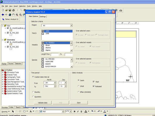
ArcGIS Server is the latest fully featured web GIS technology available on the market. Take a tour with us to explore all its potentialities!
Everybody is crazy for Google Maps now days. Do you wish to have your spatial data included into Google Earth or display them on a customized Google Map on your website? We do it for you! Click here to see some example! Email us your GIS ideas, we will prepare a proposal with our solution for free!
Let us customize your software to fit your exact needs or let us develop one just for you, from custom interfaces to batch data processing routines and reports production. We can enhance any existing software or create new ones. Tired of repeating the same routine over and over? Let the computer work at your place! What about if that unfriendly commercial software package would look like just the way you always wished? It can be done!
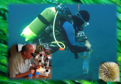
Need to asses the status and trends of your natural resources? Mappamondo GIS provides clients with a comprehensive capability for environmental resources bio-physical characterization to monitor the biological components (e.g. benthic cover, flora and fauna distributions), atmospheric conditions and emissions, liquid effluents, groundwater infiltrations, to assess environmental management actions achievements and/or ensure compliance with legal requirements. We can help on the planning, the choice of the site(s) and equipment, sensors installation and maintenance, data download, quality control and storage in database management systems, data modelling and analysis, data distribution and visualization via cartographic displays, 3D modelling and WebGIS.
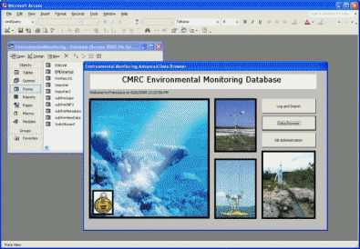
Increasingly large amounts of scientific and technical data are being created and saved in digital data storage systems. There is a need to optimize the organization, access and use of this data. A variety of different data formats need to be addressed, such as text, images, video, audio, tables, arrays, graphics, binaries, custom formats and other documents. Let Mappamondo GIS organize your data in state of the art database management systems with easy to use user interfaces, high performance access utilities, metadata maintenance tools, security features and spatial and web enabling technologies.
We are specialized in the integration of Remote Sensing and GIS for
environmental monitoring and natural resources mapping. There are strong
trends of increasing spatial and spectral resolution of remotely sensed
imagery and their application to environmental issues.
Mappamondo GIS is
specialized in retrieving, geo-referencing, ground-thruthing, enhancing,
classifying and analysing the remotely sensed data you might need for
your application.
Miscellaneous
Email info@mappamondogis.com with questions or comments about this web site.
Copyright © 2005-2010 Mappamondo GIS
VAT 02375720345 - Ph +39 02 899 26 8 26
![]()
![]()